Alem
Village in Gelderland, Netherlands

Coat of arms
51°47′13″N 5°20′37″E / 51.78694°N 5.34361°E / 51.78694; 5.34361
(2021)[1]
5335[1]
Alem is a village in the Dutch province of Gelderland. It is a part of the municipality of Maasdriel, and lies about 10 km north of 's-Hertogenbosch.
It used to part of the province in North Brabant. In 1934, it became part of Gelderland. Until 1958, Alem, Maren en Kessel was a separate municipality. The villages of Maren and Maren-Kessel are now part of the municipality of Lith.[3]
History
It was first mentioned in 1107 as Aleym. The etymology is unclear.[4] The village developed along the Maas. The Dutch Reformed Church has probably been built around 1719 using material from a previous church lost in a 1717 flood.[5] In 1840, it was home to 307 people.[3]
In 1925, the canalisation of the Maas resulted in Alem becoming a river island.[5] In 1934, it became part of the province of Gelderland.[3]
Gallery
-
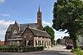
 Scene in Alem
 -
 Saint Odradastreet with village inn "Het Hart van Alem"
 -
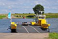 Ferry across the river Meuse


References
- ^ a b c "Kerncijfers wijken en buurten 2021". Central Bureau of Statistics. Retrieved 22 March 2022.
- ^ "Postcodetool for 5335JK". Actueel Hoogtebestand Nederland (in Dutch). Het Waterschapshuis. Retrieved 22 March 2022.
- ^ a b c "Alem". Plaatsengids (in Dutch). Retrieved 23 March 2022.
- ^ "Alem - (geografische naam)". Etymologiebank (in Dutch). Retrieved 23 March 2022.
- ^ a b Ronald Stenvert & Sabine Broekhoven (2000). "Alem" (in Dutch). Zwolle: Waanders. ISBN 90 400 9406 3. Retrieved 22 March 2022.
Wikimedia Commons has media related to Alem.
- v
- t
- e
Populated places in the municipality of Maasdriel
- Alem
- Ammerzoden
- Hedel
- Heerewaarden
- Hoenzadriel
- Hurwenen
- Rossum
- Velddriel
- Well
- Wellseind [nl]
 | This Gelderland location article is a stub. You can help Wikipedia by expanding it. |
- v
- t
- e


