Grade I listed buildings in South Kesteven
Map all coordinates using OpenStreetMap
Download coordinates as:
- KML
- GPX (all coordinates)
- GPX (primary coordinates)
- GPX (secondary coordinates)
There are over 9,000 Grade I listed buildings in England. This page is a list of these buildings in the district of South Kesteven in Lincolnshire.
South Kesteven
| Name | Location | Type | Completed [note 1] | Date designated | Grid ref.[note 2] Geo-coordinates | Entry number [note 3] | Image |
|---|---|---|---|---|---|---|---|
| Church of St Martin | Ancaster | Church | Saxon | 20 September 1966 | SK9827043573 52°58′50″N 0°32′16″W / 52.980502°N 0.537803°W / 52.980502; -0.537803 (Church of St Martin) | 1062422 | 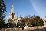 More images |
| Aslackby Manor House | Aslackby and Laughton | Hall House | 16th century | 30 October 1968 | TF0841630413 52°51′37″N 0°23′28″W / 52.860296°N 0.391139°W / 52.860296; -0.391139 (Aslackby Manor House) | 1062750 |  More images |
| Church of St James | Aslackby and Laughton | Church[1] | c. 1300 | 30 October 1968 | TF0853730394 52°51′36″N 0°23′22″W / 52.860101°N 0.389349°W / 52.860101; -0.389349 (Church of St James) | 1062757 |  More images |
| Church of St Martin | Barholm and Stowe | Parish Church | 11th century | 30 October 1968 | TF0900610976 52°41′08″N 0°23′20″W / 52.685518°N 0.388841°W / 52.685518; -0.388841 (Church of St Martin) | 1360165 |  More images |
| Church of St Nicholas | Barkston | Parish Church | 12th century | 20 September 1955 | SK9329041524 52°57′47″N 0°36′45″W / 52.962978°N 0.612541°W / 52.962978; -0.612541 (Church of St Nicholas) | 1317449 |  More images |
| Church of All Saints | Barrowby | Parish Church | 13th century | 20 September 1966 | SK8786436492 52°55′07″N 0°41′41″W / 52.918671°N 0.694662°W / 52.918671; -0.694662 (Church of All Saints) | 1194848 |  More images |
| Church of St. John the Baptist | Baston | Parish Church | Early 13th century | 30 October 1968 | TF1137713982 52°42′43″N 0°21′10″W / 52.712048°N 0.352764°W / 52.712048; -0.352764 (Church of St. John the Baptist) | 1062701 |  More images |
| Belton House | Belton Park, Belton and Manthorpe | Country House | 1685-1688 | 19 February 1952 | SK9298139300 52°56′35″N 0°37′04″W / 52.943045°N 0.617777°W / 52.943045; -0.617777 (Belton House) | 1235523 |  More images |
| Church of Saint Peter and Saint Paul | Belton, Belton and Manthorpe | Parish Church | c. 1200 | 20 September 1951 | SK9298339533 52°56′43″N 0°37′04″W / 52.945139°N 0.617681°W / 52.945139; -0.617681 (Church of Saint Peter and Saint Paul) | 1298472 |  More images |
| Stables to Belton Park | Belton Park, Belton and Manthorpe | Tea Room | 1994 | 19 February 1952 | SK9285939394 52°56′38″N 0°37′10″W / 52.943911°N 0.619565°W / 52.943911; -0.619565 (Stables to Belton Park) | 1235620 |  More images |
| Church of St. Andrew | Billingborough | Church | c. 1300 | 30 October 1968 | TF1178834244 52°53′39″N 0°20′23″W / 52.894031°N 0.339763°W / 52.894031; -0.339763 (Church of St. Andrew) | 1317596 |  More images |
| Church of St Mary Magdalene | Lower Bitchfield, Bitchfield and Bassingthorpe | Parish Church | 11th century | 20 September 1966 | SK9830528397 52°50′39″N 0°32′31″W / 52.844119°N 0.541869°W / 52.844119; -0.541869 (Church of St Mary Magdalene) | 1062863 |  More images |
| Church of St Thomas a Becket | Bassingthorpe, Bitchfield and Bassingthorpe | Parish Church | Mid-12th century | 20 September 1966 | SK9660628539 52°50′45″N 0°34′01″W / 52.845702°N 0.567044°W / 52.845702; -0.567044 (Church of St Thomas a Becket) | 1062858 |  More images |
| The Manor House | Bassingthorpe, Bitchfield and Bassingthorpe | House | C20 | 19 February 1952 | SK9878728730 52°50′49″N 0°32′05″W / 52.847023°N 0.534614°W / 52.847023; -0.534614 (The Manor House) | 1062860 | 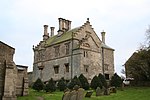 More images |
| Boothby Manor House | Boothby Pagnell | Manor House | Late 12th century | 20 September 1966 | SK9705430670 52°51′53″N 0°33′35″W / 52.864772°N 0.559761°W / 52.864772; -0.559761 (Boothby Manor House) | 1360056 |  More images |
| Church of St. Andrew | Boothby Pagnell | Parish Church | Early 12th century | 20 September 1966 | SK9718330833 52°51′58″N 0°33′28″W / 52.866213°N 0.557797°W / 52.866213; -0.557797 (Church of St. Andrew) | 1062868 | 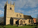 More images |
| Parish Church of St Peter and St Paul | Bourne | Church | Possibly pre 1138 | 2 May 1949 | TF0969219985 52°45′59″N 0°22′32″W / 52.766334°N 0.375692°W / 52.766334; -0.375692 (Parish Church of St Peter and St Paul) | 1260249 | 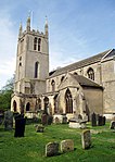 More images |
| Church of St. Margaret | Braceborough and Wilsthorpe | Parish Church | 14th century | 30 October 1968 | TF0825013297 52°42′23″N 0°23′57″W / 52.706526°N 0.399258°W / 52.706526; -0.399258 (Church of St. Margaret) | 1360151 | 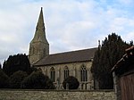 More images |
| Church of St Thomas a Becket | Burton Coggles | Parish Church | 12th century | 20 September 1966 | SK9796925839 52°49′16″N 0°32′51″W / 52.821192°N 0.547623°W / 52.821192; -0.547623 (Church of St Thomas a Becket) | 1317197 |  More images |
| Church of St. Stephen | Careby, Careby Aunby and Holywell | Parish Church | 12th century | 30 October 1968 | TF0257016482 52°44′11″N 0°28′56″W / 52.736253°N 0.4823°W / 52.736253; -0.4823 (Church of St. Stephen) | 1360059 |  More images |
| Church of St. Stephen | Carlby | Parish Church | c. 1200 | 30 October 1968 | TF0496913894 52°42′45″N 0°26′51″W / 52.712536°N 0.447609°W / 52.712536; -0.447609 (Church of St. Stephen) | 1360153 |  More images |
| Church of St Nicholas | Carlton Scroop | Parish Church | 12th century | 20 September 1966 | SK9476445005 52°59′38″N 0°35′23″W / 52.994002°N 0.589585°W / 52.994002; -0.589585 (Church of St Nicholas) | 1062428 |  More images |
| Church of St James | Castle Bytham | Church | Early 13th century | 30 October 1968 | SK9886218348 52°45′13″N 0°32′12″W / 52.753711°N 0.536636°W / 52.753711; -0.536636 (Church of St James) | 1360095 |  More images |
| Church of St Vincent | Caythorpe | Parish Church | 13th century | 20 September 1966 | SK9389448566 53°01′34″N 0°36′05″W / 53.026155°N 0.601509°W / 53.026155; -0.601509 (Church of St Vincent) | 1317320 |  More images |
| Church of St. Peter | Claypole | Parish Church | c. 1300 | 20 September 1966 | SK8456048994 53°01′54″N 0°44′26″W / 53.031556°N 0.740526°W / 53.031556; -0.740526 (Church of St. Peter) | 1062912 | 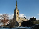 More images |
| Church of St John the Baptist | Colsterworth | Church | 11th century | 20 September 1966 | SK9302724155 52°48′25″N 0°37′17″W / 52.806933°N 0.621415°W / 52.806933; -0.621415 (Church of St John the Baptist) | 1360309 |  More images |
| Woolsthorpe Manor House | Woolsthorpe-by-Colsterworth, Colsterworth | Farmhouse | Early 17th century | 19 February 1952 | SK9240924399 52°48′33″N 0°37′50″W / 52.809232°N 0.630511°W / 52.809232; -0.630511 (Woolsthorpe Manor House) | 1062362 |  More images |
| Church of St John | Corby Glen | Parish Church | 12th century | 30 October 1968 | TF0013625002 52°48′48″N 0°30′57″W / 52.813273°N 0.515734°W / 52.813273; -0.515734 (Church of St John) | 1309158 | 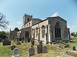 More images |
| Willoughby Memorial Library and Art Gallery | Corby Glen | School | 1669 | 6 May 1956 | SK9997524876 52°48′44″N 0°31′05″W / 52.812171°N 0.51816°W / 52.812171; -0.51816 (Willoughby Memorial Library and Art Gallery) | 1062848 | 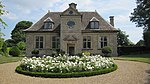 More images |
| Church of St Peter | Counthorpe and Creeton | Parish Church | Late 12th century | 30 October 1968 | TF0145719880 52°46′01″N 0°29′52″W / 52.766998°N 0.497728°W / 52.766998; -0.497728 (Church of St Peter) | 1166154 | 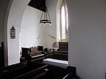 More images |
| Cross Shaft on south side of Church of St. Peter, 6m from South Doorway | Counthorpe and Creeton | Cross | 10th century | 15 December 1986 | TF0145219872 52°46′01″N 0°29′52″W / 52.766927°N 0.497804°W / 52.766927; -0.497804 (Cross Shaft on south side of Church of St. Peter, 6m from South Doorway) | 1062822 |  |
| Cross Shaft on West Side of Church of St. Peter, 12m North-west of Tower | Counthorpe and Creeton | Cross | 10th century | 15 December 1986 | TF0143719883 52°46′01″N 0°29′53″W / 52.767029°N 0.498023°W / 52.767029; -0.498023 (Cross Shaft on West Side of Church of St. Peter, 12m North-west of Tower) | 1166266 | 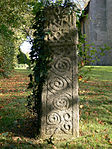 |
| 3 Table Tombs 6m from South Side of Church of St.james | Deeping St. James | Table Tomb | Mid-18th century | 22 June 1987 | TF1575309577 52°40′18″N 0°17′22″W / 52.671549°N 0.289567°W / 52.671549; -0.289567 (3 Table Tombs 6m from South Side of Church of St.james) | 1164988 |  Upload Photo |
| Church of St. James | Deeping St. James | Church | 18th century | 30 October 1968 | TF1575109592 52°40′18″N 0°17′23″W / 52.671684°N 0.289591°W / 52.671684; -0.289591 (Church of St. James) | 1062680 |  More images |
| Village Cross | Deeping St. James, South Kesteven | Village Cross | 15th century | 30 October 1968 | TF1581709486 52°40′15″N 0°17′19″W / 52.670717°N 0.288653°W / 52.670717; -0.288653 (Village Cross) | 1062681 |  More images |
| Church of St Andrew | Denton | Parish Church | c. 1200 | 20 September 1966 | SK8654432515 52°52′59″N 0°42′55″W / 52.883143°N 0.715346°W / 52.883143; -0.715346 (Church of St Andrew) | 1062370 |  More images |
| Gateway (known as Inigo Jones Gateway) 90m South East of Denton Manor, in Denton Park | Denton | Gate | Mid-17th century | 21 September 1979 | SK8619732397 52°52′56″N 0°43′14″W / 52.882138°N 0.720532°W / 52.882138; -0.720532 (Gateway (known as Inigo Jones Gateway) 90m South East of Denton Manor, in Denton Park) | 1360336 |  More images |
| Church of All Saints | Dunsby | Church | Early 12th century | 30 October 1968 | TF1052126821 52°49′39″N 0°21′40″W / 52.827592°N 0.361103°W / 52.827592; -0.361103 (Church of All Saints) | 1165123 |  More images |
| Church of St Mary and St Andrew | Stoke Rochford, Easton | Parish Church | 11th century | 20 September 1966 | SK9205227351 52°50′09″N 0°38′06″W / 52.835822°N 0.634975°W / 52.835822; -0.634975 (Church of St Mary and St Andrew) | 1147858 |  More images |
| Church of St Michael and All Angels | Edenham | Parish Church | C8, C12, C13, C15, early C16, 1808 | 30 October 1968 | TF0621021829 52°47′01″N 0°25′36″W / 52.7836°N 0.42668°W / 52.7836; -0.42668 (Church of St Michael and All Angels) | 1146587 |  More images |
| Grimsthorpe Castle and North Court | Grimsthorpe Park, Edenham | Castle | Medieval | 6 May 1952 | TF0445622778 52°47′33″N 0°27′09″W / 52.792469°N 0.452373°W / 52.792469; -0.452373 (Grimsthorpe Castle and North Court) | 1062823 |  More images |
| Church of All Saints | Fenton | Parish Church | 12th century | 20 September 1966 | SK8785250686 53°02′46″N 0°41′28″W / 53.046232°N 0.69099°W / 53.046232; -0.69099 (Church of All Saints) | 1062914 |  More images |
| Church of St. Andrew | Folkingham | Church | Late 12th century | 30 October 1968 | TF0712633731 52°53′25″N 0°24′33″W / 52.89037°N 0.4092°W / 52.89037; -0.4092 (Church of St. Andrew) | 1062733 |  More images |
| Church of St. Peter | Foston | Parish Church | Late 12th century | 20 September 1966 | SK8586742963 52°58′38″N 0°43′22″W / 52.977148°N 0.722643°W / 52.977148; -0.722643 (Church of St. Peter) | 1360062 |  More images |
| Church of St Nicholas | Fulbeck | Parish Church | 10th century | 20 September 1966 | SK9475650438 53°02′34″N 0°35′17″W / 53.042826°N 0.588111°W / 53.042826; -0.588111 (Church of St Nicholas) | 1166164 |  More images |
| Church of St Sebastian | Great Gonerby | Parish Church | c. 1200 | 20 September 1966 | SK8978438117 52°55′59″N 0°39′56″W / 52.932957°N 0.665665°W / 52.932957; -0.665665 (Church of St Sebastian) | 1062882 |  More images |
| Church of the Holy Cross | Great Ponton | Parish Church | Late 13th century | 20 September 1966 | SK9249030473 52°51′50″N 0°37′39″W / 52.863804°N 0.627591°W / 52.863804; -0.627591 (Church of the Holy Cross) | 1062347 |  More images |
| Church of St. Thomas a Becket | Greatford | Parish Church | 11th century | 30 October 1968 | TF0860611964 52°41′40″N 0°23′40″W / 52.694476°N 0.39443°W / 52.694476; -0.39443 (Church of St. Thomas a Becket) | 1317480 |  More images |
| Church of St. Andrew | Haconby | Church | Late 12th century | 30 October 1968 | TF1067225262 52°48′49″N 0°21′34″W / 52.813552°N 0.35939°W / 52.813552; -0.35939 (Church of St. Andrew) | 1360134 |  More images |
| St Mary and St Peter’s Church | Harlaxton | Parish Church | Late 12th century | 20 September 1966 | SK8826832644 52°53′02″N 0°41′23″W / 52.884023°N 0.689698°W / 52.884023; -0.689698 (St Mary and St Peter’s Church) | 1187962 |  More images |
| Forecourt Gateway and Screen at Harlaxton Manor | Harlaxton | Gate | c1840-1854 | 19 February 1952 | SK8946132325 52°52′51″N 0°40′19″W / 52.880959°N 0.672062°W / 52.880959; -0.672062 (Forecourt Gateway and Screen at Harlaxton Manor) | 1236557 |  |
| Harlaxton Manor | Harlaxton | Country House | 1832-1844 | 19 February 1952 | SK8953432282 52°52′50″N 0°40′16″W / 52.880561°N 0.670989°W / 52.880561; -0.670989 (Harlaxton Manor) | 1298440 |  More images |
| Walls Steps and Gazebos to South West of Forecourt at Harlaxton Manor | Harlaxton | Balustrade | c1838-1854 | 24 September 1979 | SK8947532277 52°52′50″N 0°40′19″W / 52.880525°N 0.671867°W / 52.880525; -0.671867 (Walls Steps and Gazebos to South West of Forecourt at Harlaxton Manor) | 1187969 | 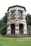 More images |
| Church of St Michael | Heydour | Parish Church | 12th century | 20 September 1966 | TF0096739618 52°56′40″N 0°29′56″W / 52.944462°N 0.49888°W / 52.944462; -0.49888 (Church of St Michael) | 1166347 |  More images |
| Church of St Wilfrid | Honington | Parish Church | 11th century | 20 September 1966 | SK9432643390 52°58′46″N 0°35′48″W / 52.979566°N 0.596579°W / 52.979566; -0.596579 (Church of St Wilfrid) | 1062413 |  More images |
| Church of St. Andrew | Horbling | Church | c. 1170 | 30 October 1968 | TF1188735179 52°54′09″N 0°20′17″W / 52.902412°N 0.33797°W / 52.902412; -0.33797 (Church of St. Andrew) | 1165999 |  More images |
| Church of All Saints | Hougham | Church | 11th century | 20 September 1966 | SK8866044221 52°59′17″N 0°40′51″W / 52.988°N 0.680714°W / 52.988; -0.680714 (Church of All Saints) | 1062889 | 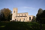 More images |
| Church of All Saints | Hough-on-the-Hill | Parish Church | 11th century | 20 September 1966 | SK9232346406 53°00′25″N 0°37′32″W / 53.007017°N 0.625542°W / 53.007017; -0.625542 (Church of All Saints) | 1360316 | 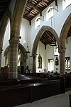 More images |
| Church of St Bartholomew | Ingoldsby | Parish Church | 12th century | 20 September 1966 | TF0102230064 52°51′31″N 0°30′04″W / 52.858597°N 0.501028°W / 52.858597; -0.501028 (Church of St Bartholomew) | 1146549 |  More images |
| Church of St Andrew | Irnham | Parish Church | 12th century | 30 October 1968 | TF0234726675 52°49′40″N 0°28′57″W / 52.827893°N 0.482418°W / 52.827893; -0.482418 (Church of St Andrew) | 1308771 | 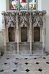 More images |
| Irnham Hall | Irnham | Country House | c. 1200 | 6 May 1952 | TF0229626642 52°49′39″N 0°28′59″W / 52.827606°N 0.483185°W / 52.827606; -0.483185 (Irnham Hall) | 1146898 | 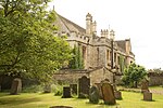 More images |
| Church of St Mary and All Saints | Kirkby Underwood | Church | 11th century | 30 October 1968 | TF0698127045 52°49′49″N 0°24′49″W / 52.830319°N 0.413548°W / 52.830319; -0.413548 (Church of St Mary and All Saints) | 1166122 | 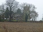 More images |
| Church of St. Michael | Langtoft | Parish Church | Early 13th century | 30 October 1968 | TF1234112552 52°41′56″N 0°20′20″W / 52.698999°N 0.338989°W / 52.698999; -0.338989 (Church of St. Michael) | 1062653 | 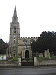 More images |
| Church of St Peter | Lenton, Lenton, Keisby and Osgodby | Parish Church | 13th century | 20 September 1966 | TF0258830351 52°51′39″N 0°28′40″W / 52.86088°N 0.477687°W / 52.86088; -0.477687 (Church of St Peter) | 1253206 |  More images |
| Church of St Medard and St Gildard | Little Bytham | Church | Early 13th century | 30 October 1968 | TF0129318036 52°45′02″N 0°30′03″W / 52.750458°N 0.500727°W / 52.750458; -0.500727 (Church of St Medard and St Gildard) | 1062772 |  More images |
| Church of St Guthlac | Little Ponton, Little Ponton and Stroxton | Parish Church | 11th century[2] | 20 September 1966 | SK9248732234 52°52′47″N 0°37′38″W / 52.87963°N 0.627136°W / 52.87963; -0.627136 (Church of St Guthlac) | 1062312 |  More images |
| South Gates to Belton Park | Londonthorpe, Londonthorpe and Harrowby Without | Gate | Early 18th century | 20 September 1966 | SK9259937812 52°55′47″N 0°37′26″W / 52.929739°N 0.623884°W / 52.929739; -0.623884 (South Gates to Belton Park) | 1261877 |  More images |
| Church of St Swithin | Long Bennington | Parish Church | Early 13th century | 20 September 1966 | SK8436143883 52°59′08″N 0°44′41″W / 52.985655°N 0.744826°W / 52.985655; -0.744826 (Church of St Swithin) | 1062891 | 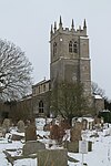 More images |
| Church of St. Guthlac | Market Deeping | Church | 1710 | 30 October 1968 | TF1368210312 52°40′43″N 0°19′12″W / 52.678591°N 0.319927°W / 52.678591; -0.319927 (Church of St. Guthlac) | 1165217 |  More images |
| The Old Rectory and the East Wing | Market Deeping | House | Mid-18th century | 6 May 1952 | TF1372310329 52°40′43″N 0°19′10″W / 52.678735°N 0.319315°W / 52.678735; -0.319315 (The Old Rectory and the East Wing) | 1062659 | Upload Photo |
| Church of St. Mary | Marston | Parish Church | c. 1175 | 20 September 1966 | SK8928643719 52°59′00″N 0°40′18″W / 52.983384°N 0.67153°W / 52.983384; -0.67153 (Church of St. Mary) | 1146946 |  More images |
| Church of St John the Baptist | Morton and Hanthorpe | Church | Mid-12th century | 30 October 1968 | TF0982624010 52°48′09″N 0°22′20″W / 52.802475°N 0.372357°W / 52.802475; -0.372357 (Church of St John the Baptist) | 1166383 |  More images |
| Church of St Mary | North Witham | Church | 11th century | 20 September 1966 | SK9280521870 52°47′11″N 0°37′31″W / 52.786436°N 0.625355°W / 52.786436; -0.625355 (Church of St Mary) | 1360327 |  More images |
| Church of St Andrew | Pickworth | Parish Church | 12th century | 20 September 1984 | TF0441633679 52°53′26″N 0°26′58″W / 52.890435°N 0.44948°W / 52.890435; -0.44948 (Church of St Andrew) | 1253286 |  More images |
| Church of St Andrew | Sempringham, Pointon and Sempringham | Parish Church | c. 1170 | 30 October 1968 | TF1065232896 52°52′56″N 0°21′26″W / 52.882153°N 0.357099°W / 52.882153; -0.357099 (Church of St Andrew) | 1241280 |  More images |
| Church of St Andrew | Rippingale | Church | Mid-13th century | 30 October 1968 | TF0978027815 52°50′12″N 0°22′18″W / 52.836675°N 0.371762°W / 52.836675; -0.371762 (Church of St Andrew) | 1260603 |  More images |
| Church of St Peter | Ropsley, Ropsley and Humby | Parish Church | 11th century | 20 September 1984 | SK9926834220 52°53′47″N 0°31′33″W / 52.89627°N 0.525803°W / 52.89627; -0.525803 (Church of St Peter) | 1261821 |  More images |
| Church of Saint Lawrence | Sedgebrook | Parish Church | Early 13th century | 20 September 1966 | SK8575738095 52°56′00″N 0°43′32″W / 52.933417°N 0.725567°W / 52.933417; -0.725567 (Church of Saint Lawrence) | 1236949 | 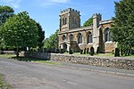 More images |
| Church of St James | Skillington | Parish Church | 11th century | 20 September 1966 | SK8955425898 52°49′23″N 0°40′21″W / 52.823184°N 0.672444°W / 52.823184; -0.672444 (Church of St James) | 1168300 |  More images |
| Church of St John the Baptist | South Witham | Parish Church | Late 12th century | 20 September 1966 | SK9271819409 52°45′52″N 0°37′38″W / 52.764334°N 0.627341°W / 52.764334; -0.627341 (Church of St John the Baptist) | 1062325 |  More images |
| Bastion | Stamford | Bastion | Medieval | 22 May 1954 | TF0251006974 52°39′03″N 0°29′10″W / 52.65082°N 0.486146°W / 52.65082; -0.486146 (Bastion) | 1360072 |  |
| Brazenose College Gate. Retaining Walls of College. | Stamford | Gate | 14th century | 22 May 1954 | TF0337907358 52°39′15″N 0°28′23″W / 52.654106°N 0.473186°W / 52.654106; -0.473186 (Brazenose College Gate. Retaining Walls of College.) | 1360017 | 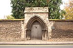 More images |
| Church of All Saints | Stamford | Church | 12th century | 22 May 1954 | TF0285207154 52°39′09″N 0°28′52″W / 52.652373°N 0.481037°W / 52.652373; -0.481037 (Church of All Saints) | 1062310 |  More images |
| Church of St George | Stamford | Church | 12th century | 22 May 1954 | TF0320307083 52°39′06″N 0°28′33″W / 52.651669°N 0.475872°W / 52.651669; -0.475872 (Church of St George) | 1168674 |  More images |
| Church of St John the Baptist | Stamford | Church | pre-C15 | 22 May 1954 | TF0292607086 52°39′06″N 0°28′48″W / 52.651748°N 0.479965°W / 52.651748; -0.479965 (Church of St John the Baptist) | 1360419 |  More images |
| Church of St Martin | Stamford | Church | c1482-1485 | 22 May 1954 | TF0311206788 52°38′57″N 0°28′38″W / 52.649035°N 0.477309°W / 52.649035; -0.477309 (Church of St Martin) | 1169102 |  More images |
| Church of St Mary | Stamford | Church | By 12th century | 22 May 1954 | TF0304307054 52°39′05″N 0°28′42″W / 52.651438°N 0.478246°W / 52.651438; -0.478246 (Church of St Mary) | 1062961 |  More images |
| Remains of St Leonard's Priory | Stamford | Benedictine Monastery | c. 1090 | 22 May 1954 | TF0389007372 52°39′15″N 0°27′56″W / 52.654135°N 0.46563°W / 52.654135; -0.46563 (Remains of St Leonard's Priory) | 1062210 |  More images |
| Ornamental Archway 250m South West from Stoke Rochford Hall | Stoke Rochford Park, Stoke Rochford | Arch | 1676 | 14 July 1978 | SK9169927692 52°50′20″N 0°38′24″W / 52.838947°N 0.640118°W / 52.838947; -0.640118 (Ornamental Archway 250m South West from Stoke Rochford Hall) | 1168574 |  |
| Ornamental Archway, 350m South of Stoke Rochford Hall | Stoke Rochford Park, Stoke Rochford | Arch | 1676 | 14 July 1978 | SK9193027596 52°50′17″N 0°38′12″W / 52.838045°N 0.636716°W / 52.838045; -0.636716 (Ornamental Archway, 350m South of Stoke Rochford Hall) | 1168585 |  |
| Seats, Balustrades and Terraces to East of Stoke Rochford Hall | Stoke Rochford Park, Stoke Rochford | Terrace | 1841-5 | 9 January 1987 | SK9187828073 52°50′32″N 0°38′14″W / 52.84234°N 0.637354°W / 52.84234; -0.637354 (Seats, Balustrades and Terraces to East of Stoke Rochford Hall) | 1360353 | Upload Photo |
| Stoke Rochford Hall | Stoke Rochford Park, Stoke Rochford | Country House | 1841-5 | 14 July 1978 | SK9183628061 52°50′32″N 0°38′17″W / 52.84224°N 0.637981°W / 52.84224; -0.637981 (Stoke Rochford Hall) | 1306963 |  More images |
| Church of St. Mary | Swinstead | Parish Church | c. 1200 | 30 October 1968 | TF0186022454 52°47′24″N 0°29′27″W / 52.790053°N 0.490957°W / 52.790053; -0.490957 (Church of St. Mary) | 1360128 |  More images |
| Summer House | Swinstead | Summerhouse | c. 1720 | 15 December 1986 | TF0216022469 52°47′24″N 0°29′11″W / 52.790132°N 0.486505°W / 52.790132; -0.486505 (Summer House) | 1062789 |  More images |
| Church of St. Lawrence | Tallington | Parish Church | Mid-12th century | 30 October 1968 | TF0913707859 52°39′27″N 0°23′17″W / 52.657482°N 0.387935°W / 52.657482; -0.387935 (Church of St. Lawrence) | 1360195 |  More images |
| Church of St Firmin | Thurlby | Parish Church | 11th century | 30 October 1968 | TF1050516802 52°44′15″N 0°21′53″W / 52.737567°N 0.364719°W / 52.737567; -0.364719 (Church of St Firmin) | 1062615 |  More images |
| Casewick Hall | Casewick, Uffington, South Kesteven[3] | House | Md | 6 May 1952 | TF0768309015 52°40′05″N 0°24′33″W / 52.66816°N 0.409045°W / 52.66816; -0.409045 (Casewick Hall) | 1165624 |  More images |
| Church of St Michael and All Angels | Uffington | Parish Church | c. 1200 | 30 October 1968 | TF0615507743 52°39′25″N 0°25′55″W / 52.657031°N 0.432041°W / 52.657031; -0.432041 (Church of St Michael and All Angels) | 1062590 |  More images |
| Church of St Bartholomew | Welby | Parish Church | 13th century | 20 September 1966 | SK9754038184 52°55′56″N 0°33′01″W / 52.932208°N 0.550292°W / 52.932208; -0.550292 (Church of St Bartholomew) | 1253411 |  More images |
| Church of St Andrew | West Deeping | Parish Church | Early 13th century | 30 October 1968 | TF1090308623 52°39′50″N 0°21′42″W / 52.663989°N 0.361581°W / 52.663989; -0.361581 (Church of St Andrew) | 1165761 |  More images |
| Church of All Saints | Westborough, Westborough and Dry Doddington | Parish Church | 11th century | 20 September 1966 | SK8501744299 52°59′21″N 0°44′06″W / 52.98929°N 0.734948°W / 52.98929; -0.734948 (Church of All Saints) | 1253495 |  More images |
| Church of St Andrew | Witham on the Hill | Parish Church | 12th century | 30 October 1968 | TF0529716589 52°44′12″N 0°26′31″W / 52.736691°N 0.441892°W / 52.736691; -0.441892 (Church of St Andrew) | 1240073 |  More images |
| Angel and Royal | Grantham | Coaching Inn | Late 14th century | 8 May 1950 | SK9136835966 52°54′48″N 0°38′34″W / 52.91336°N 0.642711°W / 52.91336; -0.642711 (Angel and Royal) | 1062486 |  More images |
| Extensions of Angel and Royal Hotel on North Side of Front Block | Grantham | Inn | 18th century | 20 April 1972 | SK9136435979 52°54′49″N 0°38′34″W / 52.913477°N 0.642767°W / 52.913477; -0.642767 (Extensions of Angel and Royal Hotel on North Side of Front Block) | 1360252 | Upload Photo |
| Church of St Wulfram | Grantham | Parish Church and Chained Library | 10th century | 8 May 1950 | SK9149836145 52°54′54″N 0°38′27″W / 52.914947°N 0.640728°W / 52.914947; -0.640728 (Church of St Wulfram) | 1062501 | 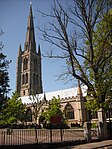 More images |
| Grantham House | Grantham | House | 14th century | 8 May 1950 | SK9155136151 52°54′54″N 0°38′24″W / 52.914991°N 0.639938°W / 52.914991; -0.639938 (Grantham House) | 1062508 |  More images |
| Stable Buildings to Grantham House | Grantham | Stable | Late 16th century | 8 May 1950 | SK9153436181 52°54′55″N 0°38′25″W / 52.915264°N 0.640182°W / 52.915264; -0.640182 (Stable Buildings to Grantham House) | 1360263 | 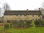 More images |
| King's School ('Old School' fronting Church Street) | Grantham | School | 1497 | 8 May 1950 | SK9148936190 52°54′55″N 0°38′27″W / 52.915352°N 0.640849°W / 52.915352; -0.640849 (King's School ('Old School' fronting Church Street)) | 1360231 | 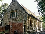 More images |
| School House (Headmaster's Residence) | Grantham | Privy House | Medieval | 8 May 1950 | SK9147936216 52°54′56″N 0°38′28″W / 52.915588°N 0.64099°W / 52.915588; -0.64099 (School House (Headmaster's Residence)) | 1062519 |  More images |
References
- ^ Historic England. "Church of St James, Aslackby (Grade I) (1062757)". National Heritage List for England. Retrieved 30 August 2013.
- ^ Historic England. "St. Guthlac's Church, Little Ponton (325757)". Research records (formerly PastScape). Retrieved 1 September 2013.
- ^ Historic England. "DMV at Casewick (347796)". Research records (formerly PastScape). Retrieved 1 September 2013.
Notes
- ^ The date given is the date used by Historic England as significant for the initial building or that of an important part in the structure's description.
- ^ Sometimes known as OSGB36, the grid reference is based on the British national grid reference system used by the Ordnance Survey.
- ^ The "List Entry Number" is a unique number assigned to each listed building and scheduled monument by Historic England.
External links
- v
- t
- e
- Bedfordshire
- Berkshire
- Bristol
- Buckinghamshire
- Cambridgeshire
- Cheshire
- Cornwall
- Cumbria
- Derbyshire
- Devon
- Dorset
- Durham
- East Sussex
- East Riding of Yorkshire
- Essex
- Gloucestershire
- Greater London
- Greater Manchester
- Hampshire
- Herefordshire
- Hertfordshire
- Isle of Wight
- Kent
- Lancashire
- Leicestershire
- Lincolnshire
- Merseyside
- Norfolk
- North Yorkshire
- Northamptonshire
- Northumberland
- Nottinghamshire
- Oxfordshire
- Rutland
- Shropshire
- Somerset
- South Yorkshire
- Staffordshire
- Suffolk
- Surrey
- Tyne and Wear
- Warwickshire
- West Midlands
- West Sussex
- West Yorkshire
- Wiltshire
- Worcestershire
- Babergh
- Bath and North East Somerset
- Bradford
- Brighton and Hove
- Broadland
- Cheltenham
- Cheshire East
- Cheshire West and Chester
- Cotswold
- Craven
- Dartford
- Dover
- Forest Heath
- Forest of Dean
- Ipswich
- Maidstone
- Mendip
- Mid Suffolk
- North Somerset
- Sedgemoor
- South Gloucestershire
- South Somerset
- St Edmundsbury
- Stroud
- Suffolk Coastal
- Taunton Deane
- Tewkesbury
- Waveney
- West Somerset
- Churches
- War memorials
- 20th century


