Mezzolombardo
Comune in Trentino-Alto Adige/Südtirol, Italy
Location of Mezzolombardo

46°13′N 11°6′E / 46.217°N 11.100°E / 46.217; 11.100
(Dec. 2006)[2]
38017
Mezzolombardo (local dialect: Mezombart) is a comune (municipality) in Trentino in the northern Italian region Trentino-Alto Adige/Südtirol, located about 15 kilometres (9 mi) north of the city of Trento. As of 31 December 2006, it had a population of 6,498 and an area of 13.8 square kilometres (5.3 sq mi).[3]
Mezzolombardo borders the following municipalities: Ton, Mezzocorona, Spormaggiore, San Michele all'Adige, Fai della Paganella, Nave San Rocco, and Zambana.
The inhabitants are called Mezzolombardesi or rarely Forcoloti. Behind the latter demonym there is a bizarre story: its inhabitants were nicknamed Forcoloti for having attacked the inhabitants of nearby Mezzocorona with pitchforks while they attempted to burn a crucifix (thus earning the nickname Brusacristi) located on the border between the two municipalities.[4]
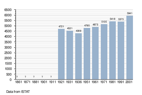
Demographic evolution
Climate
| Climate data for Mezzolombardo (1971–2000) | |||||||||||||
|---|---|---|---|---|---|---|---|---|---|---|---|---|---|
| Month | Jan | Feb | Mar | Apr | May | Jun | Jul | Aug | Sep | Oct | Nov | Dec | Year |
| Mean daily maximum °C (°F) | 6.1 (43.0) | 9.6 (49.3) | 14.6 (58.3) | 18.2 (64.8) | 23.1 (73.6) | 26.7 (80.1) | 29.6 (85.3) | 29.3 (84.7) | 24.5 (76.1) | 18.3 (64.9) | 11.1 (52.0) | 6.3 (43.3) | 18.1 (64.6) |
| Daily mean °C (°F) | 1.7 (35.1) | 4.3 (39.7) | 8.8 (47.8) | 12.5 (54.5) | 17.2 (63.0) | 20.5 (68.9) | 22.9 (73.2) | 22.7 (72.9) | 18.4 (65.1) | 12.8 (55.0) | 6.2 (43.2) | 2.2 (36.0) | 12.5 (54.5) |
| Mean daily minimum °C (°F) | −2.6 (27.3) | −0.9 (30.4) | 3.0 (37.4) | 6.8 (44.2) | 11.4 (52.5) | 14.2 (57.6) | 16.3 (61.3) | 16.1 (61.0) | 12.2 (54.0) | 7.4 (45.3) | 1.4 (34.5) | −2.0 (28.4) | 6.9 (44.5) |
| Average precipitation mm (inches) | 51 (2.0) | 45 (1.8) | 65 (2.6) | 86 (3.4) | 92 (3.6) | 93 (3.7) | 87 (3.4) | 75 (3.0) | 95 (3.7) | 116 (4.6) | 79 (3.1) | 53 (2.1) | 937 (37) |
| Source: Istituto Superiore per la Protezione e la Ricerca Ambientale [5] | |||||||||||||
References
- ^ "Superficie di Comuni Province e Regioni italiane al 9 ottobre 2011". Italian National Institute of Statistics. Retrieved 16 March 2019.
- ^ "Popolazione Residente al 1° Gennaio 2018". Italian National Institute of Statistics. Retrieved 16 March 2019.
- ^ All demographics and other statistics: Italian statistical institute Istat.
- ^ "Soprannomi di Mezzolombardo e Mezzocorona" (in Italian). Retrieved 19 May 2024.
- ^ "Valori climatici normali di temperatura e precipitazione in Italia" (PDF). Istituto Superiore per la Protezione e la Ricerca Ambientale. Retrieved 2 July 2024.
External links
- (in Italian) Homepage of the city
- v
- t
- e
- Ala
- Albiano
- Aldeno
- Altavalle
- Altopiano della Vigolana
- Amblar-Don
- Andalo
- Arco
- Avio
- Baselga di Pinè
- Bedollo
- Besenello
- Bieno
- Bleggio Superiore
- Bocenago
- Bondone
- Borgo Chiese
- Borgo d'Anaunia
- Borgo Lares
- Borgo Valsugana
- Brentonico
- Bresimo
- Caderzone Terme
- Calceranica al Lago
- Caldes
- Caldonazzo
- Calliano
- Campitello di Fassa
- Campodenno
- Canal San Bovo
- Canazei
- Capriana
- Carisolo
- Carzano
- Castel Condino
- Castel Ivano
- Castello Tesino
- Castello-Molina di Fiemme
- Castelnuovo
- Cavalese
- Cavareno
- Cavedago
- Cavedine
- Cavizzana
- Cembra Lisignago
- Cimone
- Cinte Tesino
- Cis
- Civezzano
- Cles
- Comano Terme
- Commezzadura
- Contà
- Croviana
- Dambel
- Denno
- Dimaro Folgarida
- Drena
- Dro
- Fai della Paganella
- Fiavé
- Fierozzo
- Folgaria
- Fornace
- Frassilongo
- Garniga Terme
- Giovo
- Giustino
- Grigno
- Imer
- Isera
- Lavarone
- Lavis
- Ledro
- Levico Terme
- Livo
- Lona-Lases
- Luserna
- Madruzzo
- Malè
- Massimeno
- Mazzin
- Mezzana
- Mezzano
- Mezzocorona
- Mezzolombardo
- Moena
- Molveno
- Mori
- Nago-Torbole
- Nogaredo
- Nomi
- Novaledo
- Novella
- Ospedaletto
- Ossana
- Palù del Fersina
- Panchià
- Peio
- Pellizzano
- Pelugo
- Pergine Valsugana
- Pieve Tesino
- Pieve di Bono-Prezzo
- Pinzolo
- Pomarolo
- Porte di Rendena
- Predaia
- Predazzo
- Primiero San Martino di Castrozza
- Rabbi
- Riva del Garda
- Romeno
- Roncegno Terme
- Ronchi Valsugana
- Ronzo-Chienis
- Ronzone
- Rovereto
- Roveré della Luna
- Ruffrè-Mendola
- Rumo
- Sagron Mis
- Samone
- San Giovanni di Fassa
- San Lorenzo Dorsino
- San Michele all'Adige
- Sant'Orsola Terme
- Sanzeno
- Sarnonico
- Scurelle
- Segonzano
- Sella Giudicarie
- Sfruz
- Soraga di Fassa
- Sover
- Spiazzo
- Spormaggiore
- Sporminore
- Stenico
- Storo
- Strembo
- Telve
- Telve di Sopra
- Tenna
- Tenno
- Terragnolo
- Terre d'Adige
- Terzolas
- Tesero
- Tione di Trento
- Ton
- Torcegno
- Trambileno
- Trento
- Tre Ville
- Valdaone
- Valfloriana
- Vallarsa
- Vallelaghi
- Vermiglio
- Vignola-Falesina
- Villa Lagarina
- Ville d'Anaunia
- Ville di Fiemme
- Volano
- Ziano di Fiemme

Authority control databases | |
|---|---|
| International |
|
| National |
|
 | This Trentino-Alto Adige/Südtirol location article is a stub. You can help Wikipedia by expanding it. |
- v
- t
- e


