Oja-Beyt, Iran
Town in Mazandaran, Iran
Oja-Beyt جاءبِيت | |
|---|---|
town | |
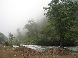 Countryside near Oja Beyt | |
| 36°31′00″N 51°10′00″E / 36.51667°N 51.16667°E / 36.51667; 51.16667 | |
| Country |  Iran Iran |
| Province | Mazandaran |
| County | Chalus |
| Bakhsh | Kelardasht |
| Elevation | 1,372 m (4,501 ft) |
| Population (2006) | |
| • Total | 4,768 |
| Time zone | UTC+3:30 (IRST) |
| • Summer (DST) | UTC+4:30 (IRDT) |
Oja-Beyt also known as جاءبِيت is a town in Chalus County, Iran.[1] It is located at latitude 36° 29' 28" N and longitude 51° 08' 36" E. It lies at an altitude of 1372 metres in the Alborz mountains, 50 km to the north of Tehran, and 25 km south of the Caspian Sea.[2]
The population is 476, and it is near the Alam-Kuh mountain and Sardab River.
References
- v
- t
- e
Mazandaran Province, Iran
- Mount Damavand
- Abbas Abad Historical Complex
- Lar National Park
- Badab-e Surt
- Mausoleum of Mir Bozorg
- Davazdah Cheshmeh
- Dasht-e Naz National Park
- Gohar Tepe
- Larijan Hot Spring
- Imamzadeh Abbas of Sari
- Resket Tower
- Shahandasht Waterfall
- Tomb of Haydar Amuli
- Miankaleh peninsula
- Farahabad Complex
- Watchtower of Babol
- Mollana Mosque
- Dohezar Forest
- Lajim Tower
- Kangelo Castle
- Sisangan Forest Park
- Challdareh National Park
- Veresk Bridge
- Mohammad Hassan Khan Bridge
- Chaikhoran Palace
- Namakabrood Aerial tramway
- Javaher Deh
- Nima Yooshij House
- Sefid Chah Cemetery
- Ab Pari Waterfall
- Kolbadi House
- Lake of Ghosts
- Mijran Lake
- Safi Abad Palace
- Gharmerez spa
- Avidar Lake
- Alendan lake
- Lar Dam
- Azad Kuh
- Alasht
- Kolakchal
- Deryuok
- Sari Clock Square
- Tamishan Palace
- Gerdkooh Hills
- Filband
- Alam-Kuh
- Jameh Mosque of Amol
- Jameh Mosque of Babol
- Jameh Mosque of Sari
- Palaeolithic Hotu and Kamarband Caves
- Markuh Castle
- Galehgardan
- Vaziri Bath of Sari
- Ramsar Palace
- Dalkhani Jungle
- Paein Lamouk Park
- Babol Museum
- Khoshedaran Museum of natural history
- Kandolus
- Sari's clock square
- Palace of Behshahr
- Churat Lake
- Gol-e Zard Cave
- Tirkan Waterfall
- Danial Cave
- Babolsar Boating Pier
- Elimalat Lake
- Gabri Tonekabon
- Espahbod Khorshid Cave
- Mirza Kuchak Khan Forest Park
- Alimastan Village
- Imamzadeh Kati Hill
- Moalagh Bridge
- Ramsar Hotel
- Nassereddin Shah relief
- Kashpel Forest Park
- Shur Mast Lake
- Baliran Jungle
- Kheshtpol Bridge
- Valasht lake of Kelardasht
- Tomb of Sultan Mohammad Taher
- Takor Tekyeh
- Sorkh Roud Wetland
- Dokhaharan lake
- Qaleh Gardan
- Malek Bahman Castle
- Chehel dar Castle
- Gazou Waterfall
- Cheshmeh Kileh Bridge
- Sangeno Waterfall
- DD Center Amir Abad
- Ecobiology Garden Nowshahr
- Saghanefar
 Iran portal

 | This Chalus County location article is a stub. You can help Wikipedia by expanding it. |
- v
- t
- e


